ERJD: Mark diagram 20-Jun-2014
|
Mark and site detail
|
Geodetic Code:
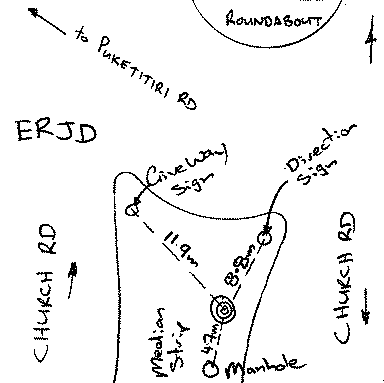
ERJD
|
|
Name:
PIN 5 SO 477872
|
Mark type:
Pin
|
|
Land District:
Hawkes Bay
|
Plan References:
SO 477872
|
|
Topo50 Reference:
BK39 310 195
|
NZTM:
5619476
1930964
|
|
|
Date established:
01-May-2014
|
Date of Inspection:
* 20-Jun-2014
|
|
Mark Description:
* Steel pin set in concrete in plastic box and cover. Stamped with Geodetic Code.
|
|
Mark Protection Structure Type:
* Plastic Cover.
Aluminium ID plate
|
|
GNSS Suitability:
|
|
Public ownership:
Unknown
|
|
|
|
|
Access Restrictions:
No restrictions
|
|
Access Notes:
central traffic island sth of church/puketitiri roundabout
|
|
Access Date:
|
|
Cellphone coverage:
Telecom: Good, Vodafone: Good
|
|
|
Access Diagram:
May not be to scale
|
|
|
|
Date Beacon Erected:
|
|
Beacon Type:
Not Beaconed
|
|
Beacon Measurement date:
* 20-Jun-2014
|
|
Beacon Eccentricity:
|
|
|
Beacon Diagram:
|

|
|
*
The data in Landonline may be more recent