BAYF: Mark diagram 11-Mar-2022
(Superceded)
|
Mark and site detail
(Superceded)
|
Geodetic Code:
BAYF
|
|
Name:
SS 137B SO 20191
|
Mark type:
Pin
|
|
Land District:
Canterbury
|
Plan References:
SO 20191
|
|
Topo50 Reference:
BZ19 550 848
|
NZTM:
5084789
1455022
|
|
|
Date established:
24-Nov-1997
|
Date of Inspection:
* 11-Mar-2022
|
|
Mark Description:
* This mark is used for deformation monitoring, do not alter the ground mark in any way. Stainless Steel Pin set in concrete under cast iron cover. Bronze ID plaque.
|
|
Mark Protection Structure Type:
* Cast Iron Cover.
Marker Post.
Aluminium ID plate
|
|
GNSS Suitability:
|
|
Public ownership:
Unknown
|
|
|
|
|
Access Restrictions:
Normal TMP
|
|
Access Notes:
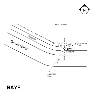
Located in footpath/cycleway on north side of Gleniti Road opposite number 244. Road is 0.5m below mark.
|
|
Access Date:
|
|
Cellphone coverage:
Spark: Good, Vodafone: Good, 2Degrees: Not Tested
|
|
|
Access Diagram:
May not be to scale
|
|
|
|
Date Beacon Erected:
|
|
Beacon Type:
Not Beaconed
|
|
Beacon Measurement date:
* 11-Mar-2022
|
|
Beacon Eccentricity:
|
|
|
Beacon Diagram:
|

|
|
*
The data in Landonline may be more recent