A9V6: Mark diagram 30-Apr-2015
|
Mark and site detail
|
Geodetic Code:
A9V6
|
|
Name:
L MT RICHARDSON
|
Mark type:
Pin
|
|
Land District:
Canterbury
|
Plan References:
SO 11977
|
|
Topo50 Reference:
BW22 368 188
|
NZTM:
5218847
1536831
|
|
|
Date established:
31-Dec-1880
|
Date of Inspection:
30-Apr-2015
|
|
Mark Description:
* 12mm SS pin set in 50mm Iron Tube. 27 Mar 2000: Iron Tube set in concrete block in stable ground. Buried mark not known. Mark is 0.4 metres above ground level. Identified by plate and plaque. Bronze ID plaque.
|
|
Mark Protection Structure Type:
* 2m Beacon.
Aluminium ID plate
|
|
GNSS Suitability:
|
|
Public ownership:
Unknown
|
|
|
|
|
Access Restrictions:
Phone first
|
|
Access Notes:
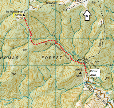
From Glentui camp on Glentui Bush Road take shingle road to picnic area. Walk approx. 2hrs along Mt Richardson track to top of mountain
|
|
Access Date:
|
|
Cellphone coverage:
Telecom: Not Tested. Vodafone: Poor. 2Degrees: Poor
|
|
|
Access Diagram:
May not be to scale
|
|
|
|
Date Beacon Erected:
|
|
Beacon Type:
Two metre metal beacon
|
|
Beacon Measurement date:
30-Apr-2015
|
|
Beacon Eccentricity:
Central
|
|
|
Beacon Diagram:
|

|
|
*
The data in Landonline may be more recent