A95W: Mark diagram 01-Aug-2015
|
Mark and site detail
|
Geodetic Code:
A95W
|
|
Name:
1621
|
Mark type:
Tube
|
|
Land District:
North Auckland
|
Plan References:
|
|
Topo50 Reference:
AV30 196 920
|
NZTM:
6092008
1719636
|
|
|
Date established:
|
Date of Inspection:
01-Aug-2015
|
|
Mark Description:
* IT (50mm dia) with steel cap. Mark is 0.13m above ground level. Bronze ID plaque.
|
|
Mark Protection Structure Type:
* 3m or 4m Beacon.
Aluminium ID plate
|
|
GNSS Suitability:
|
|
Public ownership:
Unknown
|
|
|
|
|
Access Restrictions:
Permission required before entering.
|
|
Access Notes:
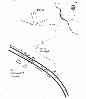
Mark located on north side of Whangaruru North Road on farmland. Access is via entrance to farm 2.3km from Rawhiti Rd approx 250m beyond the farm managers house. Follow track for 1100m then veer south onto paddock and up to trig. Total distance from road is 1800m. 2WD in fine conditions.
|
|
Access Date:
|
|
Cellphone coverage:
Spark: Good, Vodafone: Good, 2Degrees: Not Tested
|
|
|
Access Diagram:
May not be to scale
|
|
|
|
Date Beacon Erected:
|
|
Beacon Type:
3 or 4 metre wooden beacon
|
|
Beacon Measurement date:
01-Aug-2015
|
|
Beacon Eccentricity:
|
|
|
Beacon Diagram:
|

|
|
*
The data in Landonline may be more recent