A94Q: Mark diagram 07-Feb-2021
|
Mark and site detail
|
Geodetic Code:
A94Q
|
|
Name:
D POROA
|
Mark type:
Pin
|
|
Land District:
South Auckland
|
Plan References:
SO 44832
|
|
Topo50 Reference:
BE40 487 736
|
NZTM:
5773561
1948690
|
|
|
Date established:
01-Jan-1953
|
Date of Inspection:
07-Feb-2021
|
|
Mark Description:
* This mark is used for deformation monitoring, do not alter the ground mark in any way. 13mm stainless steel pin in 0.05m dia. iron pipe with concrete collar 0.11m above ground level. Inverted bottle as buried mark. Bronze ID plaque.
|
|
Mark Protection Structure Type:
* 2m Beacon.
No protection.
Aluminium ID plate
|
|
GNSS Suitability:
|
|
Public ownership:
Unknown
|
|
|
|
|
Access Restrictions:
Contact owner before entering property.
|
|
Access Notes:
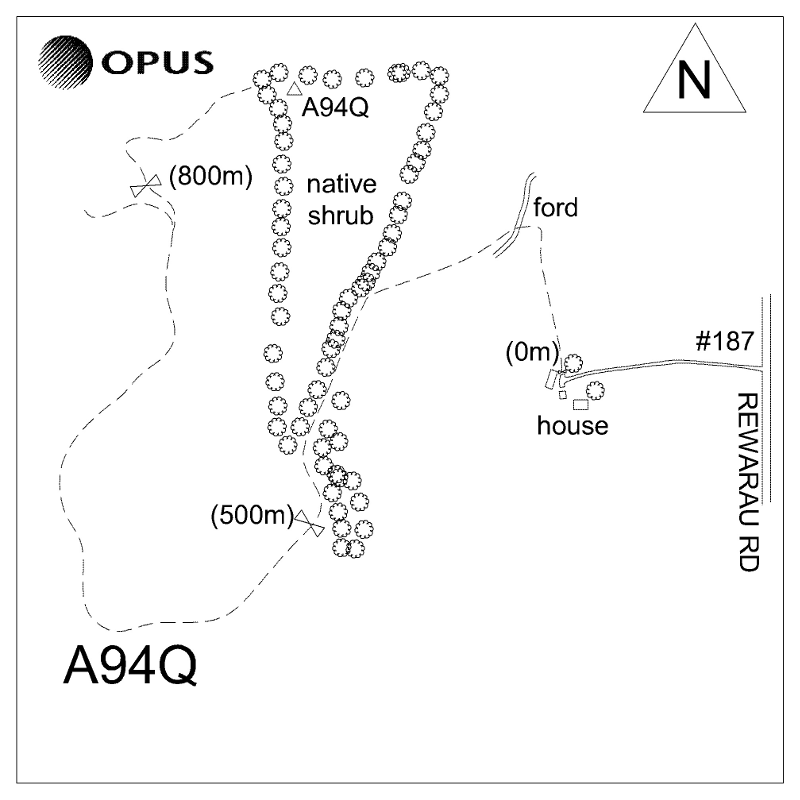
On top of hill in area overgrown with low creeper 5m south of fence and 9m east of fence corner. At 187 Rewarau Rd (0.00km) turn west into driveway. 0.12 km Turn right onto farm race ~50m before house. 0.23km Straight through single gate then immediate left through double gate just before pig sty shed. Proceed towards far left corner of paddock. 0.41km Cross ford. 0.60km Keep left on main (lightly gravelled) track, up hill. 1.06km Straight through gate and continue to follow track around back of hill. 1.64km (Park here if wet and walk ~200m) Take right fork off main track, through gate and up steep, indistinct grass track. Keeping fence on left, follow track around to the right. 1.89km Park and trig is 20m ahead. 4wd right to trig in dry conditions.
|
|
Access Date:
|
|
Cellphone coverage:
Spark: Good, Vodafone: Good, 2Degrees: Not Tested
|
|
|
Access Diagram:
May not be to scale
|
|
|
|
Date Beacon Erected:
30-Aug-1986
|
|
Beacon Type:
Two metre metal beacon
|
|
Beacon Measurement date:
07-Feb-2021
|
|
Beacon Eccentricity:
Not Central
|
|
|
Beacon Diagram:
|

|
|
*
The data in Landonline may be more recent