A92Q: Mark diagram 13-Aug-2013
|
Mark and site detail
|
Geodetic Code:
A92Q
|
|
Name:
1778 PUKEROA
|
Mark type:
Pin
|
|
Land District:
South Auckland
|
Plan References:
SO 47833, 49767, 461525
|
|
Topo50 Reference:
BF34 217 378
|
NZTM:
5737837
1821726
|
|
|
Date established:
01-Dec-1953
|
Date of Inspection:
13-Aug-2013
|
|
Mark Description:
* Stainless Steel pin grouted within 60mm dia. iron trig pipe, branded "1778", set in 0.4 x 0.4m concrete block. Pipe protrudes 0.16m above concrete block. Beacon legs set in concrete piles. Bottle as buried mark. Bronze ID plaque.
|
|
Mark Protection Structure Type:
* 2m Beacon.
Aluminium ID plate
|
|
GNSS Suitability:
|
|
Public ownership:
Unknown
|
|
|
|
|
Access Restrictions:
Courtesy Call
|
|
Access Notes:
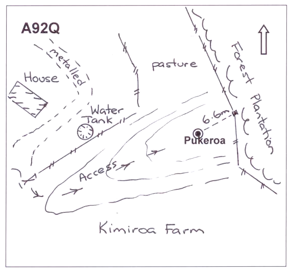
On SH.30 drive to Waitaramoa Road, Barryville. This road is located 2-3 km from both roads to Pureora, large DOC sign at road where farm track starts. Follow farm track to house, rapid No.1847, immediately south of Waitaramoa Road. Follow Kimiroa farm all weather 2WD track through several gates, past first house and old tennis court for 2.5km to farm manager's house. The beacon is clearly visible to East of house on edge of forest. 200m walk or 4WD to mark.
|
|
Access Date:
|
|
Cellphone coverage:
Vodafone: Poor, Telecom: Poor, 2 Degrees, Not Tested
|
|
|
Access Diagram:
May not be to scale
|
|
|
|
Date Beacon Erected:
28-Jan-1999
|
|
Beacon Type:
Two metre beacon
|
|
Beacon Measurement date:
13-Aug-2013
|
|
Beacon Eccentricity:
Central
|
|
|
Beacon Diagram:
|

|
|
*
The data in Landonline may be more recent