A2BM: Mark diagram 10-Feb-2011
(Superceded)
|
Mark and site detail
(Superceded)
|
Geodetic Code:
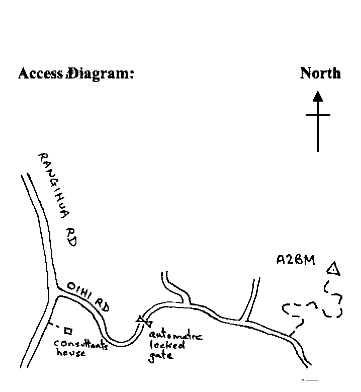
A2BM
|
|
Name:
3 MATAKA
|
Mark type:
Pin
|
|
Land District:
North Auckland
|
Plan References:
|
|
Topo50 Reference:
AV29 016 085
|
NZTM:
6108535
1701558
|
|
|
Date established:
|
Date of Inspection:
* 10-Feb-2011
|
|
Mark Description:
* 10 mm stainless steel pin in 0.05 m dia iron pipe. No known buried mark. Bronze ID plaque.
|
|
Mark Protection Structure Type:
* 3m or 4m Beacon.
Aluminium ID plate
|
|
GNSS Suitability:
|
|
Public ownership:
Unknown
|
|
|
|
|
Access Restrictions:
Locked gate
|
|
Access Notes:
On top of hill 70 m east of wooden pole aerial. Access from Purerua Rd into Rangihua Rd and into Oihi Rd (which leads to Marsden Cross)- and follow 1.3 km to locked automatic gate. Enter combination code- and follow good metalled road for 2.1 km and turn
|
|
Access Date:
|
|
Cellphone coverage:
027 OK
|
|
|
Access Diagram:
May not be to scale
|
|
|
|
Date Beacon Erected:
30-Apr-1988
|
|
Beacon Type:
* Four metre beacon
|
|
Beacon Measurement date:
* 10-Feb-2011
|
|
Beacon Eccentricity:
CENTRAL
|
|
|
Beacon Diagram:
|

|
|
*
The data in Landonline may be more recent